NEWS RELEASES
FOR IMMEDIATE RELEASE
July 9, 2008
Sandia scientists spend year developing computer model of Iraq surface water system
Task done in collaboration with Iraqi engineers and modelers
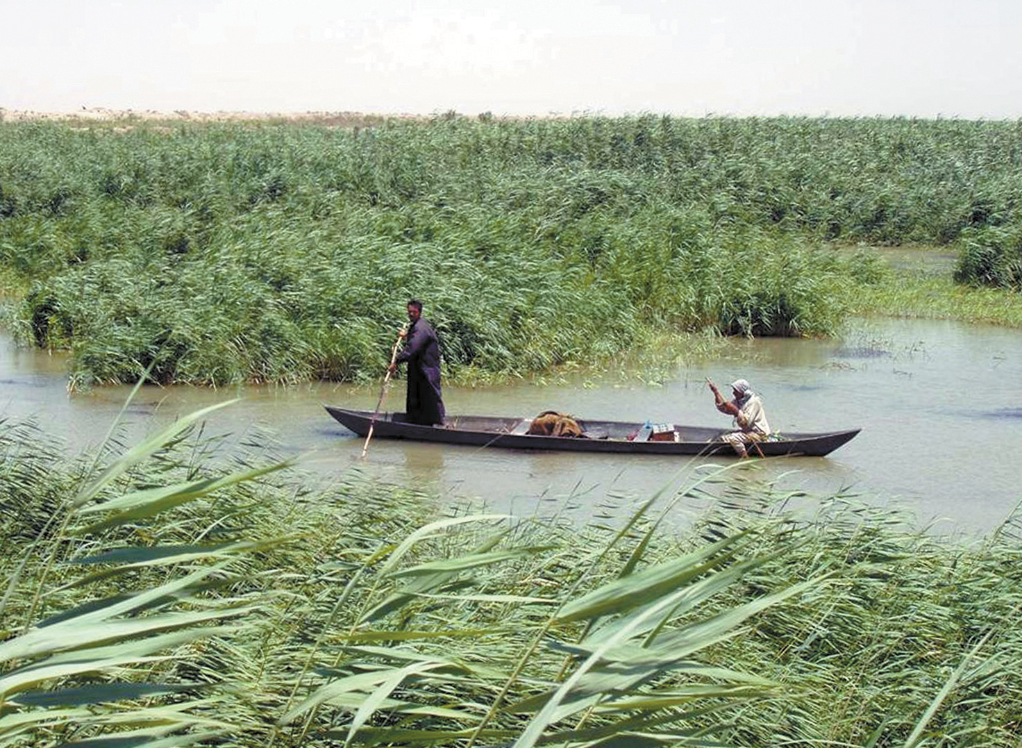
Marsh Arabs poling a traditional mashoof in the marshes of southern Iraq.The Marsh Arabs, or Ma'dan, dwell in the marshlands of the Tigris-Euphrates system in the south and east of Iraq and along the Iranian border. A Sandia team has been working with Iraqi scientists to develop a model of the nation's surface water systems. (Photo courtesy of U.S. Army Corps of Engineers. (Photo courtesy of US army Corps of Engineers )
Download 300dpi 1.40MB JPEG(Media are welcome to download/publish this image with related news stories.)
ALBUQUERQUE, N.M. — In an effort aimed at building technical capacity, resource sustainability, and regional stability, a team of scientists from Sandia National Laboratories spent the past year working with engineers and modelers from Iraq to build a computer model of the country’s surface water and related systems.
The model, aimed at assisting a longer-term national water and land planning effort by the Iraqi government, includes transboundary flows from Turkey, Syria, and Iran, along with agriculture, municipal and industrial uses, salinity, and restoration of the ecologically sensitive and culturally rich Mesopotamian Marshes in the south.
“The Iraqis recognize very clearly that the long-term stability and security of their country depends on the availability of freshwater for agriculture and for municipal and industrial uses,” says Sandia researcher Howard Passell. “We are grateful to have the opportunity to help.”
The project, funded by the U.S. Department of State’s Iraq Transition Assistance Office, included three five-day workshops over the past year. It culminated in early June with a meeting in Istanbul of all the project participants and a pressure-packed demonstration of the model by the Iraqi engineers to three of their directors from the Iraq Ministry of Water Resources (MoWR). The participants included the Sandia team of Passell, Jesse Roach, and Marissa Reno, four engineers from the MoWR, a State Department contractor from the U.S. embassy in Baghdad, and a water program manager from UNESCO. Sandia contractor Geoff Klise and Labs researcher Vince Tidwell (both 6313) also helped on the project over the course of the year in Albuquerque.
Roach says the best part of the project was watching the Iraqi engineers and modelers become engaged in the modeling process, a growing engagement that became apparent as the project unfolded. Roach was the lead modeler in the project.
“Our approach was to build the computer model in a collaborative fashion with the Iraqis,” he says. “We could have built it for them and then handed it over, but we wanted them to have ownership — to understand how the model went together and how it works. At the
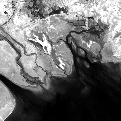
This NASA photo shows the delta region of the Tigris-Euphrates river system
in Iraq. A team of Sandia researchers worked with Iraqi scientists to
develop a computer model of Iraqi water resources.
(Media are welcome to download/publish this image with related news stories.)
end of the third workshop, our Iraqi colleagues presented the model to three high-level Iraqi Ministry of Water officials. They presented it entirely in Arabic, explained how it worked, and answered questions about everything from input data to the scenario runs they were demonstrating. It was a powerful moment in a very successful capacity-building project.”
Sandia is a National Nuclear Security Administration (NNSA) laboratory.
The model was built in a commercially available system dynamics (SD) modeling platform called Studio Expert, produced by Powersim Inc. It features short run times, user-friendly interfaces, and real-time graphical output. The Sandia Geohydrology Department staff have used the SD platform for years in collaborative, multistakeholder settings as a way of helping collaborators understand the complexities of their resource systems, identify data and information gaps, and evaluate competing resource management strategies — often in group settings, Passell says.
Over the years the Sandia water modeling group has blended this technical/social approach — bridging science and policy — to help decision makers with water, energy, and food resource management problems in New Mexico, the U.S., and internationally. They have used the approach in one form or another and have engaged scientists and engineers from more than a dozen countries, including Turkey, Syria, Iraq, Libya, Jordan, Japan, and four Central Asian republics.
The first two workshops in the Iraq project took place in Amman, Jordan, in November 2007 and February 2008. The initial workshops focused on helping the Iraqis learn to use the software and think about how the different systems associated with their resource issues were interdependent and interconnected.
By the time of the second workshop, the Sandians — with data and other information from the Iraqis — built a first draft of the model. The Iraqis used their growing skills to also build part of that version of the model.

Sandia researcher Howard Passell gives a presentation at the final water
modeling workshop in Istanbul in early June.
(Media are welcome to download/publish this image with related news stories.)
One of the critical drivers in the model is the flow of water from the headwaters of the Euphrates and Tigris rivers in Turkey to Iraq. The transboundary nature of the water resource adds a critical wrinkle in Iraqi efforts at water management.
“Surface water in Iraq is affected by infrastructure development and water operations in upstream countries,” says Reno, who built the transboundary module in the model. “Historically, Turkey and Syria were not major water users, but now both countries have developed the capacity to store and use more, and that is a major concern to Iraq.”
Just as Iraq is at risk as the downstream user in the Tigris-Euphrates system, so are the Mesopotamian Marshes at risk as the downstream user in Iraq. Labeled by some as the original Eden and populated still by the ancient Marsh Arab culture, the southern marshes once covered about 8,000 square kilometers. They are a crucial freshwater wetland ecosystem in the Arabian Gulf region. Water uses upstream have gradually reduced the area of the marshes. Saddam Hussein partially drained them in the 1990s when his enemies hid there, and they are threatened by increasing upstream water use in the future. Now they cover about 5,000 square kilometers.
“The marshes, which are culturally, historically, and economically rich and diverse, have started to dry out — partly by accident and partly by design,” says Geoff Klise, the team member who built the marsh module. “We modeled how they might be restored, looking at flows, reservoir operations, and changes to agriculture, to see how these might affect marshes downstream.”
New funding for phase two of the project is expected this month.
Sandia is a multiprogram laboratory operated by Sandia Corporation, a Lockheed Martin company, for the U.S. Department of Energy’s National Nuclear Security Administration. With main facilities in Albuquerque, N.M., and Livermore, Calif., Sandia has major R&D responsibilities in national security, energy and environmental technologies, and economic competitiveness.
Sandia news media contact: Chris Burroughs, 505-844-0948, coburro@sandia.gov